Introduction:
The History of Modern Northern Arizona and Route 66 are inseparable. Route 66 is but one of several modern and historic transportation route that cross Northern Arizona. Historically, explorers like Beale traveled the 35th parallel route, and in more modern times Route 66 shared the route with Southern Union Gas, and the Burlington Northern Santa Fe Railroad. The communities of the northland have been affected by these influences but much of their growth and prosperity has been shaped by their relationship with Route 66 and the various forms it has taken across time.
Early Roads:
Route 66 was created out of earlier, locally developed roads. In this regard then, Route 66 has roots in an earlier period of transportation. Initially, there was not a tremendous need for highways in the West after the initial wave of railroad building. The railroads performed an effective job of transporting goods and passengers across Northern Arizona. The communities served by the railroad (initially the Atlantic and Pacific, later the Santa Fe) were all small, and easily navigated on foot, or by horse. It really was not until the advent of the bicycle and later, the automobile, that there was a nationwide call for serviceable streets and highways. Road building also sprang from the Progressive Era as a way of linking the rapidly changing urban landscape with the isolated rural regions of the U.S.
As such, there were local roads which followed earlier established trails connecting one town to the next across Northern Arizona. These roads were the first roads established as official, receiving whatever care the State Engineer's Office could spare. Road building and maintenance was modeled after the railroad example with dedicated crews and equipment for specific sections of highways. For the most part, these crews did their best to keep roads smooth by grading them with drags, and providing minimal filling and cutting to reduce only the worst grades and dips.
Establishment and Building of Route 66:
Early federal highway building was based upon a number of programs which led to the creation of true inter-state highways. First, the government threw its weight behind establishing and improving so-called Postal roads, that is, roads upon which mail was to be carried. It also provided funding for states to establish roads they felt were important. These had mixed results. One initial problem was that because local highway engineers were not thinking in terms of a national system, and thus many strange little roads which benefited few were created. On the positive side, rural and urban America became linked through the Post roads initiative, decreasing the distance between the two populations. The big change came when highway builders did consider the results of linking local roads to create national highways, rather than simply building roads to connect local towns. The funds for these programs were small given the task at hand. Early roads had to be as short as possible, yet avoid fills or cuts, and bridges and tunnels as much as possible. These constraints helped to make the roads one with the environment, rather than today's highways which tend to dominate the environments through which they pass. Given these issues, Route 66 was laid out as a Northeast-Southwest highway which primarily overlaid existing roads. In Northern Arizona then, Route 66 overlay the Holbrook-Winslow highway, the Winslow-Flagstaff highway, the Flagstaff-Williams highway, and so on. There were some notable stories therein. The road from Williams to Ash Fork was a constant source of problems for road builders because of the combination of grade, water, soil and weather. Likewise the realignment of the railroad in Western Arizona caused 66 to change course a number of times.
Road building in the Northland presented a fairly overwhelming challenge given the variety of geology and terrain through which Route 66 passed. The road could not be called a "12 month" road until paving was completed in 1937.
Evolution of Route 66:
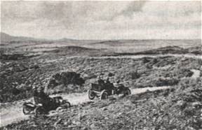
Route 66 evolved over the years in such a way that we can clearly see 4 distinct versions of the road. The first is the road as it was established in 1926. This road was simply the official designation of 66 over the existing roads of the day. With only tiny exceptions, this road was unpaved. Almost immediately following, we see the beginning of the "improvement" phase where the road was widened to federal and state specifications, and some changes were made to alter the course of 66 away from steep grades, or deep canyons. This period was followed by the paving of 66. Inclusive with paving came another round of realignment. Locally we can see examples of such realignment at Padre Canyon, Parks, the Ash Fork grade, and in other select spots across Northern Arizona. Paving was completed by late 1937. Another array of local realignment occurred after World War II. where the concrete road appeared. local examples include the Walnut Canyon-Flagstaff alignment in 1947, and the Yucca cut-off west of Kingman which bypassed Oatman in 1952. Parks and Bellmont display all three versions. Finally is the establishment of I-40. In much of Eastern Arizona, I-40 overlays 66 almost completely with a few exceptions between Holbrook and Winslow and between Winslow and Flagstaff. On the West side the new alignment I-40 cut, laid the foundation for preserving one of the longest stretches of 66, from just West of Ash Fork, to the Colorado River.
Effects of Route 66 on Northland Cities and Towns:
Generally, Northland towns were following the lead set by other Rocky Mountain communities across the West where tourists became a viable part of each localities economy, and each town worked on ways to best exploit that resource. To that end, we can see an Eastward growth for each town to grab tourists and motorists as they hit town with one sort of business or opportunity. The main streets of Northern Arizona's towns were lined with tourist/traveller-oriented enterprises; restaurants, drive-ins, curio shops, gas stations, and motels all formed the commercial sections of the town's main drag. The most extreme example of this community building along Route 66 might be Gallup, New Mexico, which has a main street nearly 14 miles long, yet most of the town is less than several blocks deep.
Route 66 traveling near the railroad tracks of the Santa Fe, often helped reinforce the separations established by the railroad so that the areas of town on the north side of the highway were often quite different from those on the south side.
Current Route 66:
The last piece of active Route 66 at Williams, Arizona was decommissioned in 1986. This event heralded a period of reflection regarding the role of Route 66 on local and national history. Across the states through which Route 66 ran, historical associations sprang up to grapple with the issues surrounding preservation of something as unwieldy as a highway, and its attendant architecture. There was a rush of book publishing. Some works were combinations of "coffee table" and popular culture works like Michael Wallis' Route 66: The Mother Road, some were personal as in the case of Tom Teague's Searching for 66, or Quinta Scott's Route 66: The Highway and Its People. Many more simply attempted to capture the "scrap-book" flavor of travel of the earlier part of this century. Many of these publications hinted at the importance of Route 66 (and the potential future for Route 66 studies), but all for the most part failed to identify just what it is about Route 66 that make such study worthwhile, and there was little agreement about what time period or version of the road's past was to be the appropriate subject of such study or preservation.
Read Full
Resources for
Route 66 Place